User: East China Investigation and Design Research Institute date: 8th January, 2007
The meaning of this case rest with:
1.The users can not solve the survey problems of the complex terrains (Lin River bluff) by using of other close-range photogrammetry systems.However by using of the Lensphoto software,assigning the terrain's feature points as the reference points,the results which users require could be gotten in an hour after survey,and the precision is higher than the users'requirement,consequently proves that the Lensphoto software has strong functions.
2.We picked up two DLGs(Digital Linear Graph) with a 1:500 scale which were respectively measured by the general water-inlet method and the Lensphoto software to compare,and then found that the superposition precision was high enough to get the users'admiration.So we should regarded the Lensphoto's survey results as the base values in the complex terrains such as Lin River bluff because that the points measured by manual method without prism often had a higher error.We could found that the precision of DEM created by Lensphoto was so high as to powerfully prove the significance of Lensphoto to users.
Water outlet:the most complex problem was that the region of water outlet was all bluffs which people could not step up, so the reference points had to be replaced by the feature points,which was also a huge trial to the Lensphoto software.
1.Photogrammetry
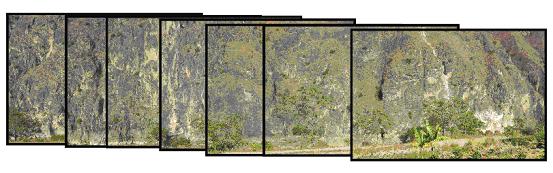
The Kodak DCS ProSLR N with Nikon 50mm camera lens was adopted The photographic distance was about 250m,photographic width about 300m,and photographic height about 100m.With the cameras without tripod were held manually,21 photos were taken in all with 7 photos gotten at every camera station respectively in the rotary manner.The distance between two stations was about 20m and the photographic time was about 10 minutes.
Graph 1: the photo taken at one camera station
2.The reference points'selection
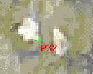
15 feature points were selected in all with 7 reference points and 8 feature points (compared to the measured coordinates). Additionally the feature points should be located in the boundary of two flat blocks with obviously different colors,other than in the cleaver cusp by reason of dispersion and refraction.
3.The reference points'measurement
Topcon 5mm Total-station Instrument without Prism GPT-3005LN/OP (Product Serial Number:1U0129) was used in the survey.A panoramic image was taken by using of wide-angle lens in advance,and then every feature point was looked for and signed simultaneously in order to make the internal photo-control-point survey conveniently.
4.Internal disposal finished in one hour
21 photos which were taken at building site and the data of reference points were inputted into the computer, and then the results of aerial triangulation encryption, TIN landscape, point clouds and the precision’s report were obtained in an hour by using of the Lensphoto software:
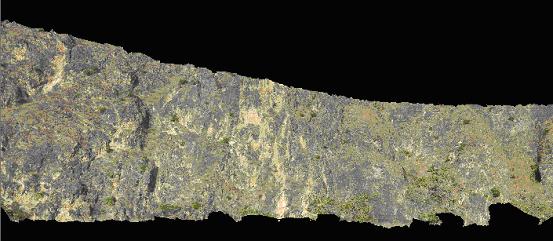
TIN landscape
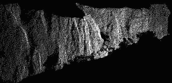
Point clouds
The precision’s report was as follows: [rmsy] was the absolute error in depth [unit m]
[precision of check points]: 8
P11 0.0359 -0.1112 0.0054
P03 0.0527 -0.0290 0.0382
P24 -0.0800 -0.0806 -0.0906
P23 -0.0040 -0.0552 0.0248
P22 -0.0297 -0.0314 -0.0112
P32 -0.0018 -0.0618 0.0540
P33 -0.0548 -0.0555 0.0092
P35 0.0745 0.0976 0.0626
[minx]:-0.0018 [maxx]: -0.0800 ( P24 )
[miny]:-0.0290 [maxy]: -0.1112 ( P11 )
[minz]:0.0054 [maxz]: -0.0906 ( P24 )
[rmsx]:0.0499 [rmsy]: 0.0709 [rmsz]: 0.0466
[rmsxy]: 0.0867(precision of plane)
[rms]: 0.0984(precision in depth)
[Mean_Deep]: 238.8517
[plane_relative_precision]: 5128
[elevation_relative_precision]: 2755
[position_relative_precision]: 2427
The precision requirement of the image with a scale 1:500 which came from East China Investigation and Design Research Institute: the precision of plane was 15cm and the precision in depth was 20cm.
The precision of the Lensphoto software's results: plane(rmsxy)<10cm,depth(rmsy)<10cm
|